FORT LAUDERDALE, Fla. — An upper-level low brought deep tropical moisture and unsettled weather to South Florida through the middle of September, producing daily downpours and street flooding.
Read more American Friends Service Committee members call on lawmakers to visit ICE facilities
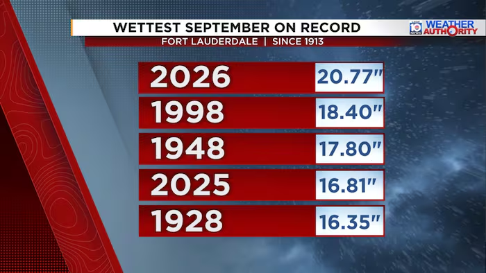
As of Wednesday morning, the Fort Lauderdale-Hollywood International Airport has received more than 20 inches of rainfall since the beginning of the month. This amount more than doubles the average rainfall for September of 8.61 inches and breaks the previous record for the wettest September for the Fort Lauderdale area set in 1998 of 18.40 inches.
This is also the wettest month in the Fort Lauderdale area since April 2023, when over 30 inches was recorded at the climate site. This included the historic rainfall of April 12-13, when flash flooding overwhelmed neighborhoods and shut down the airport.
Read more Venezuela’s acting leader, at UN for first address, promises elections at the ‘right moment’
Since last Friday, most of the rainfall has focused across Broward and northern Miami-Dade counties, with isolated amounts over 9 inches in areas like Pompano Beach, Cooper City and North Miami Beach.
While the chance for thunderstorms continues through the end of the week, the coverage of rain will be lower compared to the past week, helping to reduce the overall flood threat. A weak cold front is forecast to arrive this weekend, helping to draw in slightly drier air and drop rain chances for the weekend.
Broward
Florida Keys
Cities▾
Fort Lauderdale
Coral Springs
Davie
Deerfield Beach
Doral
Hialeah
Hollywood
Homestead
Lauderhill
Miami Beach
Miami Gardens
Miramar
Pembroke Pines
Plantation
Pompano Beach
Sunrise
Tamarac